
Finding People Along an Arapahoe County Street
An Arapahoe County street directory starts with a parcel, not a claim that every person at an address will appear. A county address can sit in an unincorporated area or inside Aurora, Centennial, Englewood, Littleton, Sheridan, or another municipality. The custodian changes with that jurisdiction. The assessor and recorder identify land and recorded parties; voter records provide a limited registration layer; directories preserve earlier address entries.
Keep the question narrow: who is listed as an owner, which parcels lie along the street, or which names appear in a dated source. The sequence below moves from current location evidence to older household clues, while keeping an owner, a registered voter, and a directory-listed occupant in their proper categories.
- Start with the assessor address range. Enter the street name and a number range in the Arapahoe County Assessor Property Search. Capture each AIN, PIN, situs address, legal description, owner list, and mailing address before opening the next parcel.
- Check the same segment in ArapaMAP. Use the county GIS viewer's Address or Parcel mode to confirm parcel geometry, jurisdiction, districts, streets, and map context. This catches a city boundary or a parcel with more than one situs address.
- Treat voter data as a limited layer. GoVoteColorado is a person match requiring first name, last name, date of birth, and residential ZIP. A county list can be requested by permitted filters, but it is not a street-name browse of every household.
- Follow the recorded deed chain. Use the assessor sales row as a lead into GovOS PublicSearch, then compare grantor, grantee, recording date, reception or book/page data, and legal description. A deed traces a recorded transfer, not day-to-day presence.
- Move back to reverse directories. Use DPL householder volumes, the 1932 and 1939 XL Arapahoe-area runs, and local newspapers to locate dated address entries. Verify the page image and pair a directory line with another source before drawing a household conclusion.
Arapahoe County Street Records by Address
A street directory is most useful when the same parcel key carries from one office to the next. In Arapahoe County, the property card supplies a current parcel and owner lead, ArapaMAP supplies geometry and jurisdiction, and the recorder supplies the legal transfer trail. Elections, permits, and historical directories add separate kinds of people-bearing evidence.
The coverage below shows what each source can contribute. The access route changes when land is inside an incorporated city, when the record is older than the online deed-name range, or when a protected person or field is omitted.
| Record Set | Keeper | What It Shows | Access |
|---|---|---|---|
| Assessor parcel card | Arapahoe County Assessor | Owner list, ownership type, AIN/PIN, situs and mailing address, legal description, values, sales, building and land fields | Free property search; assessor offices and phone support |
| ArapaMAP parcel feature | County GIS | Parcel geometry, jurisdiction, districts, aerials, streets, parcel ID, and map selection context | Free GIS viewer; extracts and map tools |
| Recorded deed or lien | Clerk and Recorder, Recording Division | Grantor, grantee, recording number/date, book/page, document type, consideration, legal description, and image status | GovOS PublicSearch; older books by appointment |
| Tax account | Arapahoe County Treasurer | PIN/AIN, address, tax account context, payment options, and notification settings | TaxSearch; office route for questions |
| Permit or application | PWD or the responsible city | Applicant, owner or agent, address/parcel, project, record type, status, related records, and attachments | Accela and PWD request for unincorporated land; city portal or request for incorporated land |
| Public voter file | Arapahoe County Elections | Permitted name, address, status, party, precinct, district, and history fields, with statutory exclusions | Basic weekday TXT or custom list request; not a complete street roster |
AIN or PIN ties the parcel card to GIS and can help narrow a recorder query. The street string ties an address to a search, but a legal description is stronger when a subdivision, unit, old road name, or boundary is involved.
Note: An address range discovers parcels along a street, but it does not prove that each listed owner lives at the situs.
Arapahoe County Street Directory Search Fields
The assessor address form is built for a street segment. Use a partial street name after at least three letters, leave out compass direction and street type, and use the number range to browse rather than guessing one parcel at a time. Results appear six per page, so record the full run before moving on.
AIN and PIN are stronger exact keys when a street search returns similar names, multiple units, or several parcels. The portal covers Arapahoe County real estate. State-assessed property is not searchable by address, and business personal property follows a separate route.
| Field | Type | Required | Street-search use |
|---|---|---|---|
| Number (from) | Text/number | No | Starting house number for a range |
| Range/To | Text/number | No | Ending number for a street segment |
| Street Name | Text | Conditionally required | At least 3 letters; partial match; omit direction and type |
| Unit | Text | No | Narrows condominium or suite records |
| AIN | Text | Required in AIN mode | Formatted identifier such as 0000-00-0-00-000; maximum 16 characters |
| PIN | Text | Required in PIN mode | Numeric, preserve leading zeroes, and begins with 03 |
| Search | Button | N/A | Runs the selected search |
| Reset | Button | N/A | Clears the search fields |
For a long street, work in ranges and save the AIN/PIN beside the street number. That simple ledger prevents a later page of results from being mistaken for the whole street directory.
Assessor help is available online, at 5334 S Prince St or the Aurora Altura Plaza office at 15400 E 14th Pl Ste 500, and by phone at 303-795-4600 or assessor@arapahoegov.com. The listed office hours are Monday through Friday, 8-4. GIS and mapping questions use 720-874-6686.
The Arapahoe County Assessor Property Search capture shows the portal's address, AIN, and PIN search paths used before a street directory is assembled.
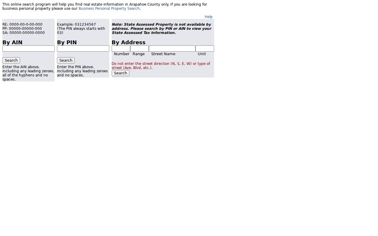
Use the search mode that matches the available key, then preserve the resulting parcel identifier with the street number.
Reading an Arapahoe County Parcel Card
The parcel card is the bridge between an address and a named record. It can show a Full Owner List, ownership type, neighborhood and code, acreage, land use, legal description, values, tax district, building characteristics, land details, linked sales, and map or sketch links. Sales rows on the inspected sample card run by tax year from 2005 through 2025 and show book/page, date, price, and transaction type.
Read the card as ownership evidence. It does not prove that every person connected with the property is present, and the listed owner may use a trust, estate, business, representative, or separate mailing address. The card disclaimer also says measurements are exterior and that a photo or sketch may not exist for every parcel.
The sales row is a lead, not a substitute for the recorded instrument. Carry its book/page or other transfer clue into GovOS, then compare the deed's parties and legal description with the card. If the street search returns a condominium or a parcel with more than one situs, use the unit and legal description to keep the records distinct.
The Arapahoe County sample parcel card shows how owner, mailing, situs, sales, building, and land fields sit together in one result.
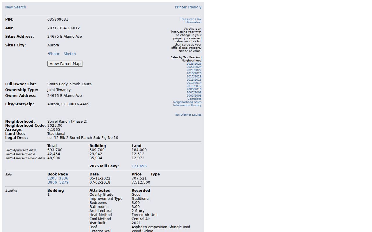
The card gives a precise starting point for the street directory, while the separate mailing and situs fields warn against treating a parcel record as a complete household list.
ArapaMAP for Arapahoe County Streets
ArapaMAP adds the geography that a text address lacks. Use Address/Parcel Info, then choose Parcel or Address locate mode. The result can show jurisdiction, parcel ID, districts, political and tax statuses, aerial context, and the street network. Parcel locate accepts a partial Parcel ID, while a PIN is a nine-digit numeric key beginning with 03.
The viewer is also useful for a repeatable street browse. Turn on parcel, aerial, and street layers, select the target feature, and keep the map scale and print date with the research notes. The county describes more than 100 layers, but the full live layer list is dynamic, so describe only the controls actually used.
- Buffer Selected Features: choose a radius and units such as feet, meters, miles, kilometers, or chains.
- Selection rules: choose whether features must be completely within the buffer and whether to include the original parcel.
- Print Map: add a title, choose 8.5x11, 11x17, 17x22, or 24x36 size, select portrait or landscape, set scale, and fit the print.
- Other controls: Advanced Query, Symbology, Select/radius, Property Photo, StreetView, and Import for spreadsheet, KML/KMZ, web service, or shapefile ZIP data.
Use the map for parcels and jurisdiction, not for naming every person near a point. Open each selected parcel's assessor card when a parcel-level ownership question remains.
The Arapahoe County ArapaMAP viewer is the source for the address, parcel, buffer, and print controls described here.
The viewer turns a street string into parcel geometry, which helps separate a county record from a city record when jurisdiction lines cross an address area.
Mailing and Situs Addresses in Arapahoe County
Situs means the physical location of the parcel. It is the address used to locate land, connect a parcel to a map, and search an address range. The mailing address is where the assessor's tax correspondence is sent to the listed owner. It may match the situs or point to another city, state, office, trust, estate, or representative.
This distinction matters in a street directory because the two fields answer different questions. Situs helps identify which land lies along the street. Mailing helps explain where a named owner receives correspondence, but it is not proof of residence and does not identify every household member. Compare the two before treating a match as meaningful.
ArapaMAP and County GIS Location Info can also expose jurisdiction and parcel context. Location Info accepts an address without adding city, state, or ZIP, but a parcel with multiple situs addresses may return only the first or a random address. Test alternatives and confirm the legal description on the card.
Note: A postal city or ZIP can differ from parcel jurisdiction, so route permits by the GIS result rather than by the mailing label alone.
Arapahoe County Deeds Before and After 1980
The recorder turns an address into a chain of recorded parties. GovOS PublicSearch offers Real Property and Marriage departments, a quick search for grantor, grantee, subdivision, document type, or document number, and advanced fields for party names, grantor, grantee, recorded date, document type, reception or document number, book/volume, page, OCR text, and legal-description groups.
The important distinction is the search key. The Digital Records FAQ describes ordinary grantor/grantee name searching and digital records from 1980 forward. The live configuration can display an index date range reaching back to June 3, 1872, but a pre-1979 name search normally requires a Reception Number or Book/Page. Older grantor/grantee books are an appointment and office-research channel.
- Search the current owner as grantee near the assessor sale date.
- Record the instrument fields: Reception Number, book, page, recorded date, grantor, grantee, document type, legal description, consideration, and image status.
- Take the grantor backward: search that party as grantee and check the lot, block, subdivision, or metes-and-bounds description.
- Repeat across the boundary: ask the Recording Division for the needed Reception Number or Book/Page route and older-book appointment when the transfer predates the digital name route.
Watermarked images are free in the portal. Unwatermarked copies cost $0.25 per page, certified copies add $1 per document, and an online card transaction adds $2. The Arapahoe County GovOS recorder search is the source for the live index and image workflow.
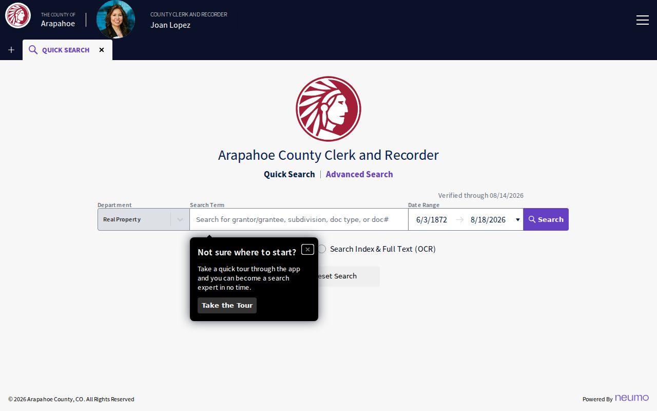
The recorder view is strongest when the street search has already supplied a parcel, sale clue, or legal description. A name alone can point to a different property or party role.
Recording Division access also includes e-recording, mail, 24-hour red drop boxes, and in-person recording by appointment. The listed offices are Littleton at 5334 S Prince St, Aurora at 490 S Chambers Rd, Byers at 538 N Hwy 36, and Centennial at 6954 S Lima St. Recording staff can be reached at 303-795-4200 or recording@arapahoegov.com.
Note: A deed names recorded parties and land interests, not every person who occupied a property during that period.
Arapahoe County Permits by Address
Unincorporated land-development records run through Arapahoe County Public Works and Development and the Accela Customer Access portal. Accela General Search can use record number, record type, project name, and date. A building application may search by address or parcel, and a record detail can show processing status, related records, attachments, owner or agent information, and the parcel or address used in the application.
When the online result is thin, PWD Records accepts requests for microfilm, digital, and paper records at 720-874-6500 or PWDRecords@arapahoegov.com. The office is at 6924 S Lima St in Centennial and reports that many email requests have no charge, while paper pages, mailing, and large retrieval work can vary. The county start date and full public permit-result columns were not located, so they should not be guessed.
Incorporated cities keep their own permits, zoning, code cases, and municipal records. Aurora's public-record search offers address, subdivision, and quarter-section modes with a category control, but the category list, result fields, and index years were not captured. Use the responsible city request route when ArapaMAP shows city jurisdiction. A county mailing label does not move a city-held record into county custody.
For a county record not exposed in a portal, a targeted Arapahoe County CORA request under the Colorado Open Records Act, C.R.S. §§24-72-201 et seq., should name the office, address or parcel, record type, date range, desired format, and whether electronic delivery is acceptable.
Historical Arapahoe County Street Directories
Modern parcel cards and deeds do not replace the address-organized collections held by Denver-area libraries and local museums. DPL householder directories cover 1924-1937, and the 1887 Denver Directory includes a by-address volume. The 1932 Western Arapahoe County XL volume includes Englewood, Fort Logan, Garden Home, Littleton, a county section, and street material. The 1939 XL Arapahoe County District section covers Fort Logan, Garden Home/Westwood, Littleton, Loretto, and Sheridan/Petersburg.
Aurora directory leads are 1953, 1955, 1957, 1959, and 1962. FamilySearch catalog item 146029 shows 1957 and 1961 suburban holdings, including Aurora-area street-guide material. Search the address section first, then verify the name in the alphabetical section. Preserve the volume, year, page, street spelling, and abbreviations such as r, rms, and b.
These are historical records, not current household rolls. OCR can misread initials, punctuation, and street numbers, so use the page image and the neighboring year. The collection-by-collection treatment belongs with the Arapahoe County city directory records, while this street directory uses the volumes only as an address bridge.
Note: A 1932 or 1939 locality label may say Western Arapahoe County, Garden Home, Westwood, or a suburban district rather than the modern city name.
Voter Visibility Along an Arapahoe County Street
GoVoteColorado asks for first name, last name, date of birth, and residential ZIP. Its return can include a current registration match, mailing address, precinct or district, party affiliation, and county clerk contact, subject to protected status. It is a person lookup, not an address-range tool.
Arapahoe Elections publishes a Basic Voter List as a weekday TXT file and offers district/history extracts, election-period files, and custom lists. The county page identifies public fields such as name, address, registration status, party, birth year, precinct, district, and permitted history. A custom county list is listed at $25 for comma-delimited TXT or $35 for Excel, while printed pages are $0.25 per page.
Public files exclude Social Security numbers, driver or ID numbers, full date of birth, signatures, email, ballot choice, confidential voters, and preregistered minors. A custom request can narrow by precinct, district, party, status, and history interval, but the research did not locate a ZIP-only or click-every-household mode. Protected voters and Address Confidentiality Program participants should never be reconstructed from absent results or substitute addresses.
GoVoteColorado, Colorado voter data rules, and the Arapahoe public voter-list page describe the available channels and exclusions.
For a custom file or a question about exclusions, contact Arapahoe Elections at 303-795-4511 or elections@arapahoegov.com. Voter Services appointments and a paper process for confidential status are separate access routes from the public download.
Terms in an Arapahoe County Street Directory
Address research crosses parcel, map, deed, and historical-directory language. The terms below keep a street search from treating a legal land record as a household roster or a postal label as a jurisdiction ruling.
Read the definition beside the source that uses it. A parcel card, plat, and criss-cross entry can all describe the same place while naming different people, dates, and kinds of interest.
- Parcel
- A mapped unit of land with an assessor and GIS identifier. A parcel may contain a structure, a unit, or more than one situs address, and it does not list every person present.
- Situs address
- The physical location assigned to the land for mapping and property records. It is separate from the listed owner's mailing address.
- Plat
- A recorded map that can connect streets, lots, blocks, subdivisions, and parcel geometry to an older legal description.
- Criss-cross directory
- A historical reverse directory organized by address or street. It can show a listed householder, business, or occupant for a dated year, but it is not proof of title or current presence.
When street spelling and legal description disagree, compare the plat, lot/block or metes-and-bounds language, parcel geometry, and the period's own street guide before declaring two entries the same address.
Street Directory Limits in Arapahoe County
No public parcel record lists every person who may be present at a property. A non-owner household member may not appear on an assessor card, a protected voter may be omitted by design, and a historical directory may list a boarder, spouse, business contact, or prior occupant without showing title.
Colorado DMV personal address and vehicle information is controlled by the federal Driver's Privacy Protection Act and the state's request forms. Utility customer accounts, delivery records, private association membership, meeting attendance, and private communications are not county street rolls. A court, deed, or voter match also needs the right date, place, and record type before it is treated as a match.
Lawful use. Arapahoe County street and address records may support personal, lawful research, family history, and house history. Colorado stalking law, C.R.S. §18-3-602, and harassment law, C.R.S. §18-9-111, prohibit using repeated records to follow, threaten, intimidate, or harm a person.
Use the named custodian for a correction or a copy, and stop when the record is protected or the purpose turns into surveillance. A precise by-address record states what its sources can and cannot establish.