
Sources for Arapahoe County Previous Residents
The previous residents of an Arapahoe County address appear in different record families, and each family answers a different question. Deeds show recorded parties, directories show listed household or business names, census schedules show a household at an enumeration point, and maps show the built setting without naming its residents.
Start with the present parcel, then choose the row that fits the period being tested. A year range in a table means the research located that run or portal behavior. It does not promise an unbroken countywide series or a complete list of everyone who lived at an address.
| Source | Years It Covers | Where Held | What It Shows |
|---|---|---|---|
| Recorder digital name index | 1980-present | Arapahoe GovOS | Grantor/grantee names, dates, document and reception data, legal descriptions, images and payment options |
| Recorder pre-digital books | Pre-1979; exact first year not located | Clerk and Recorder appointment research | Reception Number or Book/Page route and older grantor/grantee books |
| Assessor sale links | Sample card links 2005-2025 tax years | Assessor Property Search | Book/page, date, price, transaction type, and a lead into the deed index |
| PWD permit and application records | Current Accela interface; start year not located | County ACA and PWD Records | Record type, project/date, owner or parcel fill, status, related records, and attachments |
| DPL householder directories | 1924-1937 | Denver Public Library | Address-organized owners, residents, and businesses; verify the local municipal scope |
| 1887 Denver Directory | 1887 | DPL digital and physical collections | Volume 2 by address, with name and occupation volumes as companion checks |
| Western Arapahoe County XL directory | 1932 | DPL STX-2 | Englewood, Fort Logan, Garden Home, Littleton, county material, residents, businesses, and streets |
| XL Arapahoe County District | 1939 | DPL STX-2 | Fort Logan, Garden Home/Westwood, Littleton, Loretto, Sheridan/Petersburg, residents, businesses, and householder entries |
| Aurora city directories | 1953, 1955, 1957, 1959, 1962 | Aurora History Museum and official survey lead | Alphabetical city-directory resident and business listings |
| XL suburban catalog | 1957 and 1961 holdings located | FamilySearch item 146029 | Denver-area suburban scope, including Aurora, Englewood, and Littleton, with a street-guide lead |
| Littleton Independent | 1888-1923 online; later microfilm | Colorado Historic Newspapers and Littleton Museum | Announcements, obituaries, people, businesses, and address clues |
| Federal census | Latest public schedule is 1950 under the 72-year rule | NARA and library databases | Household composition, age, birthplace, and enumeration-district context; 1960 is not public in 2026 |
| Aurora Sanborn map | June 1926 | Library of Congress | Two-sheet street, building footprint, lot, and use context; no resident names |
| Probate, death, and burial sources | Arapahoe probate 1902-1967; burial ledgers 1869-1981 | 18th Judicial District, State Archives, and Columbine Society | Heirs, estate actions, death clues, and burial records with collection-specific limits |
Use the deed and assessor rows for the recent ownership trail, then move to directories, newspapers, census, maps, and probate for household context. A library or museum collection can fill a gap without changing the legal limits of a restricted vital or court record.
Note: A source year marks a collection’s coverage, not an unbroken list of every household at an Arapahoe County address.
Trace Past Owners in Arapahoe County Deeds
With the current parcel identified, save the assessor AIN, PIN, legal description, current owner list, situs address, mailing address, neighborhood or code, and sales links. The card's sale row is a useful date and book/page lead, but it is not a complete title chain and does not establish who occupied the property.
GovOS PublicSearch has Real Property and Marriage departments. Its quick search accepts grantor, grantee, subdivision, document type, or document number. Real Property advanced search adds party names, grantor, grantee, recorded-date range, document types, Reception Number or Document Number, Book/Volume, Page, OCR Text, and legal-description groups.
The Arapahoe County recorder search is the starting point for the recorded transfer index and image workflow.
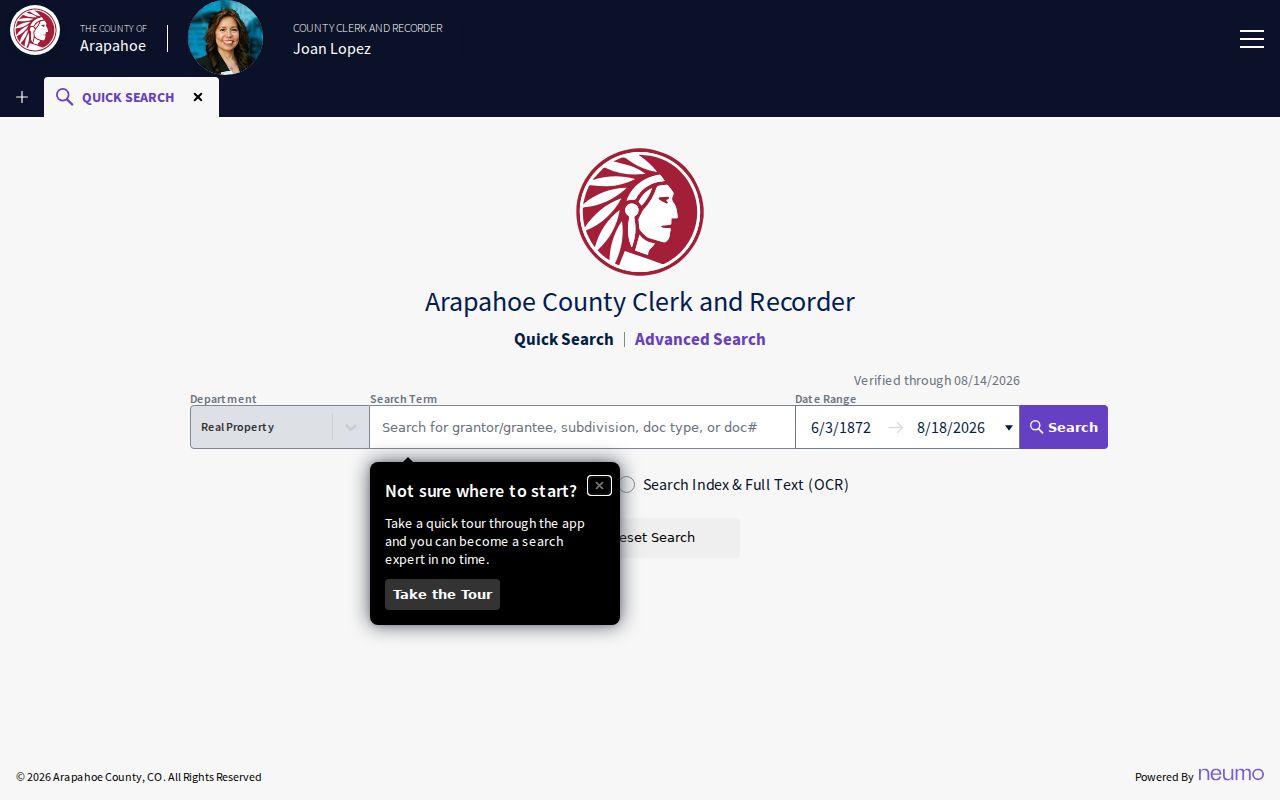
The recorder image shows the portal route, while the legal description and party roles determine whether a result belongs to the parcel under study.
- Find the current purchase deed. Search the listed owner as grantee around the assessor sale date and compare the address clue with the legal description.
- Capture the record fields. Write down grantor, grantee, Reception Number, book, page, recorded date, document type, consideration, references, and image status.
- Turn the chain around. Take the deed's grantor and search that party as grantee before the current transfer.
- Confirm land, not just names. Match lot, block, subdivision, plat, or metes-and-bounds language. Trusts, estates, corporations, and representatives can appear as parties.
- Repeat until the online boundary. Digital name searching is described for 1980-present; pre-1979 research normally needs a Reception Number or Book/Page.
- Move to the older-book route. Ask the Recording Division for the sequence and make an appointment for grantor/grantee books when the name index no longer supplies the needed key.
- Grantor / grantee
- The grantor transfers or conveys an interest. The grantee receives it. A deed may include several parties or a trust, estate, or organization rather than a household member.
- Chain of title
- The linked sequence of recorded transfers that connects a present instrument to earlier grantors and grantees for the same land.
- Legal description
- The parcel language in a deed or plat, such as lot, block, subdivision, or metes and bounds. It is often more stable than an old street number.
Watermarked copies are free in GovOS. Unwatermarked copies cost $0.25 per page, certified copies add $1 per document, and an online card transaction adds $2. Recording Division staff can be reached at 303-795-4200 or recording@arapahoegov.com.
Note: The recorder chain follows recorded instruments, so occupancy still needs a dated directory, census, or newspaper source.
Freeze Today's Arapahoe County Parcel
Begin with the current assessor card, even when the question is about previous residents. Save the AIN in its hyphenated form, the PIN with its leading zeroes, the legal description, current owner list, ownership type, situs address, mailing address, neighborhood or code, and every visible sale link. The sample card links sale-by-tax-year pages from 2005 through 2025, with book/page, date, price, and transaction type fields.
Record the inspection date and keep the parcel map link with the notes. A card can change as values, sales links, or other current fields update. It is evidence about a listed owner and parcel, not proof that the listed owner occupied the address or that every historical household member appears. The current address-keyed workflow is detailed in the Arapahoe County street directory.
Compare situs and mailing address before searching a name. A mailing address may point to another city or state, an office, a trust, an estate, or a representative. The legal description is the anchor that should survive a change in street spelling or postal label.
The Assessor offers online search, in-person service at 5334 S Prince St and the Aurora Altura Plaza office at 15400 E 14th Pl Ste 500, and help at 303-795-4600 or assessor@arapahoegov.com. For older permit clues, PWD Records keeps microfilm, digital, and paper material and can be reached at 720-874-6500 or PWDRecords@arapahoegov.com; incorporated-city files stay with the city.
Arapahoe County's GovOS Historical Boundary
The recorder portal creates a useful but uneven historical line. The live Real Property configuration displayed an index date range back to June 3, 1872 during research, while the County Digital Records FAQ describes ordinary grantor/grantee name searching and digital records from 1980-present. Those statements are not contradictory: a date range can reach earlier index material even when the ordinary name and image workflow does not.
For a transfer before 1979, begin with any known Reception Number, Book/Page, legal description, or deed reference. The older grantor/grantee books are an appointment and office-research channel. Do not assume that a failed name search means the previous residents disappeared. It may mean the search key changed. This is often the point where previous residents move from a name search to a document-number search.
Recording Division supports e-recording, mail, 24-hour red drop boxes, and in-person recording by appointment at Littleton, Aurora, Byers, and Centennial locations. The office phone is 303-795-4200 and the email is recording@arapahoegov.com. A narrow question with an address, date, party role, and legal description gives staff a better route than a broad request for everyone connected with a street. For a county-held item not exposed online, the Colorado Open Records Act, C.R.S. §§24-72-201 et seq., supplies a request route, subject to exemptions and custodian rules.
Reverse Directories for Arapahoe County Addresses
DPL's 1924-1937 householder directories are the clearest address-organized bridge located for the early twentieth century. The 1887 Denver Directory has a by-address volume, while its alphabetical and occupation volumes provide cross-checks. The 1932 Western Arapahoe County XL directory includes Englewood, Fort Logan, Garden Home, Littleton, a county section, and street material. The 1939 XL Arapahoe County District section includes Fort Logan, Garden Home/Westwood, Littleton, Loretto, Sheridan/Petersburg, and a householder section.
For Aurora, confirmed directory leads are 1953, 1955, 1957, 1959, and 1962. FamilySearch catalog item 146029 shows 1957 and 1961 suburban holdings and a street-guide lead. The catalog is not a promise that every year is present. Use the DPL Colorado Directories Index and the catalog terms Western Arapahoe County, Arapahoe County District, and XL before assuming a missing volume was never printed.
Read the address section first, then verify the same line in the alphabetical section. Keep the page, volume, locality label, street spelling, and the era's abbreviation key. OCR can turn a number or initial into a false lead, so the scan is the final check. That discipline helps distinguish previous residents from a nearby same-name entry.
Littleton Museum and Arapahoe County House History
The Littleton Museum Research Center is the strongest located local fallback when an address trail needs context rather than one more portal result. Its holdings include Littleton Independent and other newspaper microfilm, photographs, maps, oral histories, and people, business, church, school, and farm files. Materials do not circulate, and research is by appointment rather than drop-in access.
Contact the Littleton Museum Research Center at 303-795-3954 or history@LittletonCo.gov before traveling. Supply the street string, number, subdivision or plat if known, and an approximate construction or ownership period. That gives staff a way to compare an old address with local files and may clarify which previous residents appear in the local record.
Littleton Independent material is available through the online historical newspaper archive for 1888-1923; later issues and other local newspaper material route through the museum. The Aurora History Museum archive and Englewood Public Library history collection provide city-specific alternatives for Aurora and Englewood addresses. Arapahoe Libraries can help with genealogy and local history, but its district excludes Aurora, Englewood, and Littleton, so the municipal route matters.
The 1926 Sanborn Snapshot for Arapahoe County
The Library of Congress holds Sanborn Fire Insurance Map from Aurora, Adams and Arapahoe Counties, dated June 1926 and issued in two sheets. It can show a street, building footprint, lot configuration, structure use, or named institution that existed at that point. That built-environment evidence can help decide whether an older directory line belongs to the same place.
The Sanborn map does not name a household. It should be paired with a deed, directory, newspaper, or census schedule rather than used as a resident index. Compare the sheet's street and lot pattern with the current parcel geometry and legal description. If they do not line up, preserve both versions and investigate the municipal or subdivision change.
Sanborn is especially useful when a modern address appears newer than the surrounding land history. A map can date a structure or street configuration, while a directory or deed supplies the people or parties. Neither source alone proves continuous ownership or occupancy, but together they can frame where previous residents fit in time.
Note: A Sanborn sheet shows buildings and lots, not the names of people who lived in them.
Obituaries and Probate Endpoints in Arapahoe County
When a directory name disappears, a life-event record can explain the break. Littleton Independent coverage from 1888-1923 is searchable online, with later issues available through the Littleton Museum. DPL's Denver Obituary Project indexes 1913-2016. Arapahoe Libraries' newspaper databases, Aurora historic newspapers, and Englewood's local-history collection add city-specific leads.
Probate is a court record, not a recorder search. The State Archives lists Arapahoe probate holdings from 1902-1967, while an 18th Judicial District request can lead to a case file, Register of Action, will, letters, claims, or closing material when public. Guardianship, conservatorship, minor, and other protected records may require a different process or remain closed.
Columbine Genealogical and Historical Society indexes Arapahoe marriages from 1940-1965 in three published volumes and more than 8,000 burials from two ledgers covering 1869-1981. State Archives also lists Riverside Cemetery plot certificates from 1878-1899 and historic death series. These are clues and endpoints, not substitutes for a restricted certified vital record.
The 18th District records route accepts mail and email requests through ArapahoeRecordsRequest@judicial.state.co.us or 18records@judicial.state.co.us, with case number, party name, year, document type, and certification choice used to narrow a search. State Archives reference help is available at 303-866-2358. Use the specific custodian when an index lead needs a file or certified copy.
Arapahoe County's Address-Continuity Caveat
No verified countywide street-renumbering or renaming year was located in the research. That is an honest limit, not a reason to guess. A historical number may refer to a road that later acquired a new name, a suburban district, a route label, or a different municipal description.
Bridge the old and new strings with the deed's legal description, plat, lot, block, subdivision, old directory street guide, municipal history or survey, Sanborn sheet, and GIS parcel geometry. Keep the period label in the citation. A 1932 or 1939 volume may say Western Arapahoe County, Garden Home, Westwood, Sheridan/Petersburg, or Littleton even when the modern parcel uses another city name.
Place history also matters. Arapahoe County was one of Colorado's original 17 counties, Denver was the original seat, and the 1902 division moved the seat to Littleton while changing the county's footprint. A historical reference to Arapahoe County can therefore describe land now associated with Denver or another county. Search by place and year, not by today's ZIP alone.
Note: An old street label must be tied to a legal description before it is treated as the same modern address.
Past Households: Directories, Census, and Obituaries
Ownership is only one part of previous-resident research. A criss-cross directory can place a listed householder or business at an address for one year, while a federal census can show household composition at an enumeration point. Neither source turns a historical line into present-day proof. Pair the address, name, date, and place before treating an entry as a household clue. Previous residents are strongest as a dated source chain, not a single conclusion.
The collections themselves are described on the Arapahoe County city directory page. The backward trail uses them in a narrower way: one address, one dated line, then a second source that can explain a move, a death, an estate transfer, or a change in the street label.
- Hold the address steady. Write the modern street number, street name, subdivision, plat, and legal description before searching an older volume.
- Find the nearest address-organized run. Start with DPL's 1924-1937 householder volumes, the 1887 by-address volume, or the 1932 and 1939 XL Arapahoe-area sections.
- Read both directory views. Capture the address entry, then check the alphabetical name section for occupation, spouse or household markers, business addresses, and abbreviations.
- Pair the year with a census checkpoint. The latest public federal schedule is 1950 under the 72-year release rule. Use the enumeration district and household fields as a period check, not an annual record.
- Close a change with a life-event source. Search newspapers, obituaries, probate, marriage indexes, cemetery ledgers, or an estate deed when a name appears or disappears.
- Criss-cross directory
- A reverse directory arranged by street and number. It can identify a listed household or business for a publication year and may use an abbreviation key.
- Enumeration district
- The census area assigned to an enumerator. It helps locate the right schedule when a historical street label or municipal boundary differs from today's address.
Lawful house history. Previous-resident research in Arapahoe County is appropriate for family history, a property record, or personal historical study. Do not combine records to follow, threaten, harass, or track a living person. Colorado stalking law, C.R.S. §18-3-602, and harassment law, C.R.S. §18-9-111, still apply to information found in public sources.